Beyond Malta's beaches, historic cities and spectacular coastline lies a very different way to discover the island. Stretching across the Maltese countryside, the Victoria Lines form an impressive network of nineteenth-century fortifications built along a natural geological escarpment. Sometimes referred to as Malta's "Great Wall", they offer one of the island's most fascinating walking experiences.
Following the route reveals rural valleys, limestone villages, Mediterranean vegetation and sweeping views across the Maltese landscape—all while tracing an important chapter of the island's British military history.
For travellers looking for the best hikes in Malta, the Victoria Lines combine history, nature and adventure in a single journey across the island.
What Are the Victoria Lines in Malta?
The Victoria Lines are a defensive system constructed by the British during the second half of the nineteenth century. Built mainly between 1875 and 1899, the fortifications were designed to protect Malta's densely populated south and the strategically important Grand Harbour from a potential land invasion arriving from the north.
The defensive line follows the Great Fault, a natural rocky escarpment dividing parts of northern and central Malta. Originally known as the North West Front, the fortifications were renamed the Victoria Lines in 1897, the year of Queen Victoria's Diamond Jubilee.
Today, this former military boundary has become one of Malta's most distinctive hiking routes.
Why Are the Victoria Lines Called Malta's Great Wall?
The nickname "Great Wall of Malta" comes from the long stretches of defensive wall that follow the island's natural ridge.
The system was much more sophisticated than a single wall. It incorporated:
• defensive walls and ditches;
• artillery positions;
• observation posts;
• batteries;
• military bridges;
• several forts.
Among its most important defensive structures were Fort Madalena, Fort Mosta and Fort Bingemma.
The ambition was considerable: British military planners wanted to create a defensive barrier capable of stopping enemy troops advancing towards Valletta and the Grand Harbour. However, military technology evolved quickly. By the beginning of the twentieth century, exercises had demonstrated that sections of the defensive system could be bypassed. The Victoria Lines were
therefore abandoned as Malta's primary land defence in 1907, although some military structures continued to be used later.
Today, the walls no longer divide Malta. They provide a route through some of its most peaceful landscapes.
Hiking the Victoria Lines
Walking the Victoria Lines trail reveals a side of Malta that many visitors never encounter. Instead of beaches and busy promenades, the landscape is dominated by limestone plateaus, agricultural terraces, traditional dry-stone walls and
Mediterranean garrigue.
The trail follows elevated terrain for much of the route, creating panoramic views across Malta's countryside. However, hikers should not expect a perfectly continuous or fully signposted footpath. Certain sections require leaving the fortifications and following country lanes before reconnecting with the historic wall. Vegetation can also make some
sections more difficult to identify.
For this reason, downloading an offline map or GPS route before starting the hike is strongly recommended.
The Bingemma Section
One of the most beautiful sections of the Victoria Lines lies around Bingemma, in western Malta. Here, the fortifications cross a quieter rural landscape overlooking valleys and farmland. Historic military structures blend naturally into the limestone terrain, while the elevated position offers wide views across the surrounding countryside.
The old military bridge crossing the valley is one of the most distinctive landmarks along this section and a particularly photogenic reminder of the scale of the original defensive system.
For travellers who do not want to complete the entire Victoria Lines hike, Bingemma is an excellent place to experience a shorter section.
Victoria Lines Hiking Routes: Distance and Duration
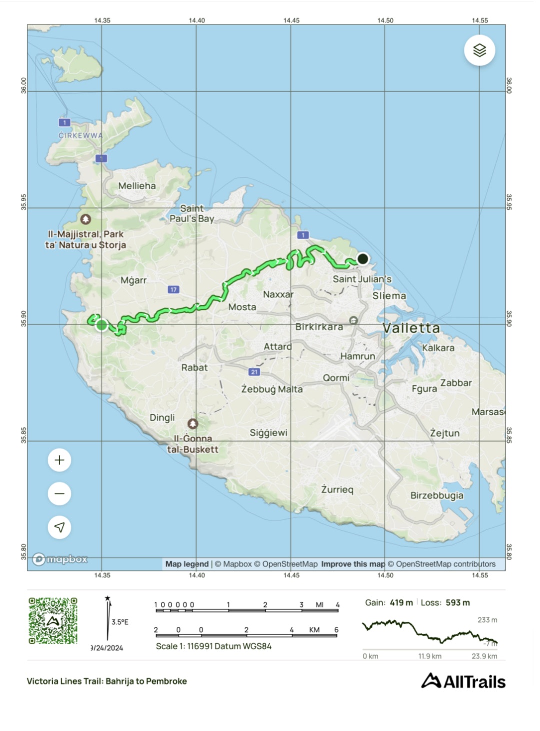
There are several ways to explore the Victoria Lines depending on your fitness level and how much time you have available.
A Short Victoria Lines Walk
For an introduction to the trail, explore a section around Mosta and Bingemma. Allow approximately 1 to 2 hours, depending on the route, your walking pace and the number of stops you make.
This is a good option for visitors who want to combine the Victoria Lines with other attractions in central Malta.
A Half-Day Victoria Lines Hike
More experienced walkers can follow a longer section connecting areas around Madliena, Naxxar, Mosta and Bingemma. Depending on the chosen route and accessible sections, allow approximately
4 to 6 hours. This option provides a much better sense of the scale of the defensive line and the changing landscapes along the Great Fault.
A Full-Day Hike
Experienced hikers can incorporate the Victoria Lines into a longer countryside walk towards Rabat, Dingli or surrounding rural trails. Extended itineraries can exceed 20 kilometres and require most of the day. Because the Victoria Lines do not always form one continuous marked trail, distances and walking times can vary considerably depending on access and detours.
Is the Victoria Lines Hike Difficult?
The Victoria Lines hike is generally of moderate difficulty. There are no major mountain climbs, but the terrain can be rocky and uneven, with regular ascents and descents created by the Great Fault. Certain sections may also become overgrown or slippery after rain.
A reasonable level of fitness is therefore recommended, particularly for anyone planning to walk a substantial part of the route. Good walking shoes are considerably more comfortable than sandals or smooth-soled footwear.
When Is the Best Time to Hike in Malta?
The best time for hiking in Malta is generally from October to April. During autumn and winter, temperatures are cooler and the Maltese countryside gradually becomes green again after the dry summer months.
Spring is particularly beautiful. Wildflowers appear across the landscape, agricultural fields are at their most colourful and the Mediterranean vegetation surrounding the trail comes alive.
Hiking the Victoria Lines during summer is possible, but conditions can become extremely hot and there is relatively little shade along parts of the route. If you visit during the warmer months, starting early in the morning is strongly
recommended.
What to Bring for the Victoria Lines Hike
Unlike Malta's urban sightseeing routes, sections of the Victoria Lines cross countryside where facilities may be limited.
Before setting out:
• wear sturdy trainers or walking shoes with good grip;
• carry sufficient drinking water;
• bring sun protection, sunglasses and a hat;
• download an offline map or GPS track;
• check weather and trail conditions;
• avoid entering unstable or restricted military structures;
• respect farmland, crops and traditional Maltese dry-stone walls.
After heavy rainfall, take extra care on rocky or uneven sections.
Combine Your Hike With Malta's Historic Villages
One of the pleasures of hiking the Victoria Lines is the opportunity to combine the trail with some of Malta's inland towns and villages.
Mosta makes a natural stop and is famous for its monumental Rotunda, while Naxxar offers traditional architecture and historic streets. Further west, Mgarr is surrounded by agricultural countryside, while nearby Rabat and Mdina can transform the hike into a full day dedicated to Malta's rural landscapes and cultural heritage.
Stopping in one of these towns for lunch is also an excellent opportunity to discover traditional Maltese food after several hours of walking.
Discover a Different Side of Malta
The Victoria Lines are more than a military monument. Walking alongside them reveals how Malta's geography shaped its strategic importance while introducing visitors to an island far removed from the familiar images of beaches, harbours and resort towns.
Here, Malta becomes an island of rocky escarpments, cultivated valleys, limestone walls and quiet country roads. For hikers, history lovers and travellers looking for unusual things to do in Malta, the Victoria Lines offer one of the most rewarding ways to explore the Island.
Hiking in Malta from The Snop House
For guests staying at The Snop House in Senglea, exploring the Victoria Lines provides a fascinating contrast with the historic architecture of the Three Cities and Grand Harbour.
After discovering Malta's maritime history, Baroque heritage and fortified cities, a day in the countryside reveals another chapter of the island's story. From British forts to Mediterranean garrigue, the Victoria Lines offer a journey through both Malta's landscape and its history. It is a reminder that some of the island's most memorable experiences begin simply by putting on a pair of walking shoes and following the path.